
Highs of 26C or 27C have been forecast for some areas of the UK next week, with the weather to improve for the start of the summer holidays.
Clouds and cooler weather have returned this weekend after the hottest day of the year so far on Friday.
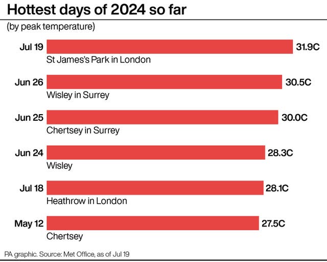
It was 31.9C at St James’ Park, central London, making Friday the warmest recorded day of 2024.
After a largely cloudy and cooler start to the weekend, there will be fresher, brighter, drier weather on Sunday. Temperatures look likely to stay around the low 20Cs, which is the July average.
Craig Snell, a meteorologist at the Met Office, told the PA news agency that the east will likely see a “grey start” to Sunday, while the south will see temperatures reach their high teens.
As the day goes on, most of the country “will see dry and bright spells”.
Into next week, rain is expected to move in from the west on Monday. The north of England, Scotland and Northern Ireland will see wet spells, while the south will remain largely untouched by rain.
The weather is likely to settle down on Tuesday and Wednesday, with temperatures starting to climb in some areas. In the south, temperatures could reach as high as 26C or 27C in a few spots.
What type of weather did you experience through Friday?
Here is a look back at the past 24 hours 👇 pic.twitter.com/stctfs5GUY
— Met Office (@metoffice) July 19, 2024
Thursday is then expected to be wet before things settle down again going into next weekend.
Mr Snell said: “It won’t be wall-to-wall sunshine and we’ll see rain in the north on Monday and the rest of the country on Thursday.
“It also won’t be as hot as recent days but warmer than the start to July. It will be an improvement.
“Overall, the south east and south are likely to see the warmest temperatures next week.”


Comments: Our rules
We want our comments to be a lively and valuable part of our community - a place where readers can debate and engage with the most important local issues. The ability to comment on our stories is a privilege, not a right, however, and that privilege may be withdrawn if it is abused or misused.
Please report any comments that break our rules.
Read the rules hereLast Updated:
Report this comment Cancel